MapList-Flat 1.4 x86 x64
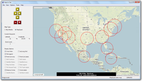
MapList-Flat is an easy to use windows program to present simple GIS data, and map grid data on a flat world map. This is a sister program to MapList-Globe, which does the same job, but on a 3D world globe instead of a flat map.
Primarily intended for mapping data produced by other Gunamoi Software applications in MapList (*.maplist) and Map Grid (*.warray) files, this application can also load and display limited information from standard GPX, GeoJSON and KML map information files. Additional functions include the ability to plot satellite pointing angles (azimuth and elevation) on a map for a satellite located at any latitude, longitude or altitude; as well as the ability to draw multiple circles on the map at a fixed distance from designated centre points. Although not of much use to most people, MapList-Flat can also plot legacy satellite pattern (*.satpat) files from our old SatBeam program; or draw elliptical (or circular) satellite beams from a specified GEO satellite location. MapList-Flat can also plot satellite orbit ground tracks from TLE orbit data files.

21MB
*
MapList-Flat is an easy to use windows program to present simple GIS data, and map grid data on a flat world map. This is a sister program to MapList-Globe, which does the same job, but on a 3D world globe instead of a flat map.
Primarily intended for mapping data produced by other Gunamoi Software applications in MapList (*.maplist) and Map Grid (*.warray) files, this application can also load and display limited information from standard GPX, GeoJSON and KML map information files. Additional functions include the ability to plot satellite pointing angles (azimuth and elevation) on a map for a satellite located at any latitude, longitude or altitude; as well as the ability to draw multiple circles on the map at a fixed distance from designated centre points. Although not of much use to most people, MapList-Flat can also plot legacy satellite pattern (*.satpat) files from our old SatBeam program; or draw elliptical (or circular) satellite beams from a specified GEO satellite location. MapList-Flat can also plot satellite orbit ground tracks from TLE orbit data files.

21MB
*