ReefMaster Waypoint Manager 1.17.30.0
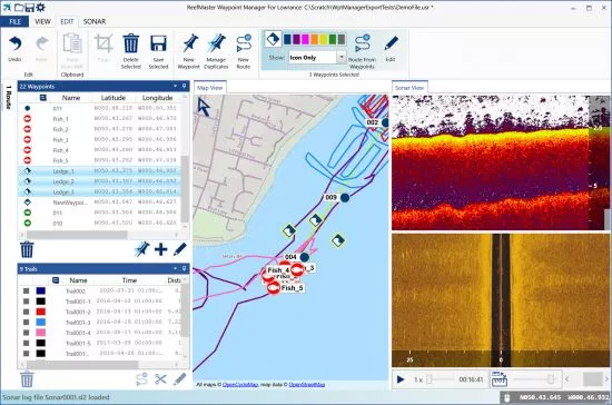
The ReefMaster Sonar Viewer is a Windows PC application that combines a multi-channel sonar viewer with the display of side-scan sonar over a world base map. The sonar viewer works with sonar logs from Lowrance and Humminbird units, and lets you view any combination of your available sonar channels with smooth playback at speeds of up to 30x. Waypoints can be created and edited in the sonar or map views, and loaded and saved in a variety of file formats.
This easy-to-use program includes waypoint, trail and route management along with a multi-channel sonar viewer. Previously tedious tasks, such as updating waypoint icons or labels, or removing duplicate waypoints, can be completed in seconds with a minimum of effort.

Display, edit and manage waypoints with full equivalent Lowrance icon and colour sets.
Display, edit and manage routes and trails, convert trails to routes and convert route-points to waypoints.
Easily select groups of waypoints, trails or routes for export, editing or deletion.
Group editing operations on waypoints and trails, including icon and colour, label visibility and more.
Import export of Lowrance USR file format in versions 3/4/5/6, Google Earth, GPX and CSV file formats. Quickly and easily convert one file type to any other.
Copy and paste trails and waypoints directly from Google Earth.
Simple to use waypoint duplicate-removal tool.
Full multi-channel sonar viewer for Lowrance SLG, SL2 and SL3 sonar log files.
Metric or US units.
File size: 20.7 MB
Download
*
The ReefMaster Sonar Viewer is a Windows PC application that combines a multi-channel sonar viewer with the display of side-scan sonar over a world base map. The sonar viewer works with sonar logs from Lowrance and Humminbird units, and lets you view any combination of your available sonar channels with smooth playback at speeds of up to 30x. Waypoints can be created and edited in the sonar or map views, and loaded and saved in a variety of file formats.
This easy-to-use program includes waypoint, trail and route management along with a multi-channel sonar viewer. Previously tedious tasks, such as updating waypoint icons or labels, or removing duplicate waypoints, can be completed in seconds with a minimum of effort.

Display, edit and manage waypoints with full equivalent Lowrance icon and colour sets.
Display, edit and manage routes and trails, convert trails to routes and convert route-points to waypoints.
Easily select groups of waypoints, trails or routes for export, editing or deletion.
Group editing operations on waypoints and trails, including icon and colour, label visibility and more.
Import export of Lowrance USR file format in versions 3/4/5/6, Google Earth, GPX and CSV file formats. Quickly and easily convert one file type to any other.
Copy and paste trails and waypoints directly from Google Earth.
Simple to use waypoint duplicate-removal tool.
Full multi-channel sonar viewer for Lowrance SLG, SL2 and SL3 sonar log files.
Metric or US units.
File size: 20.7 MB
Download
*